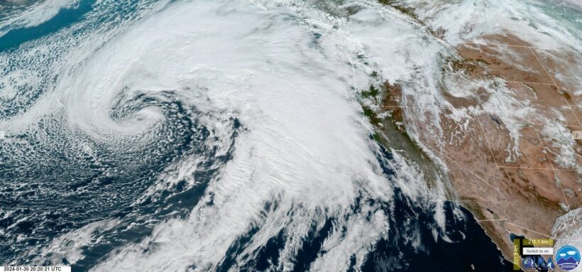
In California, more than 20 million residents were under flood alerts on Wednesday as the first of two atmospheric river storms hit the northern part of the state, reported CNN.
By Cristen Hemingway Jaynes
The “Pineapple Express” storms were expected to bring warm, moist air with gusty winds, heavy rain and snow in the highest elevations.
“An atmospheric river over the West Coast will bring heavy rainfall and gusty winds from southern Oregon to central California today, pushing south into southern California into Thursday. Heavy snowfall is expected over the Sierra and Intermountain West through Thursday,” the National Weather Service said.
The predicted heavy rains could help boost long-term freshwater supplies in the state, which have been below average this winter, Reuters reported.
Meteorologist Daniel Swain of the University of California, Los Angeles, said Pineapple Express storms originate in the warm waters around Hawaii.
Swain told reporters the first of the two storms would likely impact the San Francisco Bay Area most on Wednesday evening.
In addition to the flood watch given by the National Weather Service for the Central Coast and Bay Area, high-wind advisories were also posted for the region.
Thursday could see some streams and roads flood in the southern parts of the state, but Swain said major flooding was not as likely.
A second storm, more powerful than the first, is forecast to reach California on Sunday with more strong winds and even heavier rainfall for Southern California, plus more mountain snow.
“Suffice it to say there will be some flooding in Southern California,” Swain said, as reported by Reuters. “The question is whether it is the unremarkable street flooding we see in any big rainstorm or something considerably more significant than that.”
According to the National Weather Service, fallen trees, in addition to flooding, would be the most likely hazards from the storm, The New York Times reported.
NOAA’s Weather Prediction Center said localized flash flooding was of most concern for urban areas, roads, burn scars and small streams.
The first storm was predicted to move through quickly, reducing the amount of rainfall in any individual location.
The Northern and Central California mountains were expected to get snowfall amounting to a foot or more.
The second storm, expected on Sunday, could turn out to be a “significant atmospheric river event,” according to the Weather Prediction Center, as reported by The New York Times.
That storm could produce even more rainfall and mountain snow than the first.
“The next significant, wetter storm will arrive in California by sometime Sunday and last into early next week. Details are still a bit uncertain, but it will also have the potential to bring flooding rain, landslides and rockslides as well as mountain snow and strong winds. Impacts could be worse with this second storm given the rain will fall on ground saturated by the first storm,” The Weather Channel said.
Cristen is a writer of fiction and nonfiction. She holds a JD and an Ocean & Coastal Law Certificate from University of Oregon School of Law and an MA in Creative Writing from Birkbeck, University of London. She is the author of the short story collection The Smallest of Entryways, as well as the travel biography, Ernest’s Way: An International Journey Through Hemingway’s Life.