Rapidly intensifying hurricanes are some of the most frightening and destructive types of extreme weather.
Predicting them has been notoriously difficult for forecasters who have been unable to fully understand why some tropical storms or tropical depressions that seem commonplace can suddenly turn into major hurricanes with devastating winds and deadly storm surges.
By: Cristen Hemingway Jaynes
Now, researchers from the National Center for Atmospheric Research (NCAR) are beginning to unravel the mystery behind these deadly storms.
In a new study, they discovered there isn’t just one mechanism at work in a rapid intensification scenario, a press release from NCAR said.
The research team, led by NCAR scientist Falko Judt, used computer modeling to pinpoint two entirely separate types of rapid intensification, which could lead to better prediction and comprehension of these menacing storms. Rapid intensification is when hurricane winds increase by about 35 miles per hour within a 24-hour period.
“Trying to find the holy grail behind rapid intensification is the wrong approach because there isn’t just one holy grail,” Judt said in the press release. “There are at least two different modes or flavors of rapid intensification, and each one has a different set of conditions that must be met in order for the storm to strengthen so quickly.”
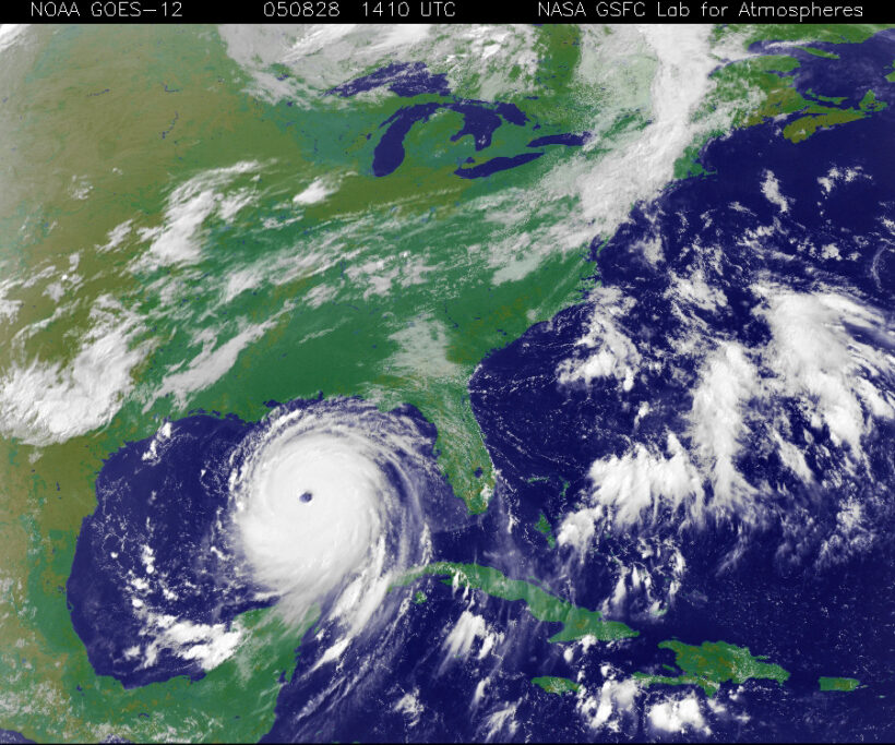
One of the modes of hurricane intensification happens when warm ocean surface temperatures — such as those that have become more common due to climate change — and low wind shear fuel a hurricane. This type of rapid strengthening happened with disastrous storms like Hurricanes Maria and Andrew.
Just this week, forecasters were taken aback when Hurricane Otis increased by 110 miles per hour in only 24 hours, making landfall in Mexico as a Category 5 storm.
The second rapid intensification mode identified by the researchers involves bursts of thunderstorms outside the storm’s center. The bursts set off a reconfiguration of the hurricane’s circulation that help it to quickly intensify to a Category 1 or 2 within hours. This mode usually occurs during unfavorable conditions like countervailing upper-level winds that blow the upper part of the storm in a different direction than the lower part.
“Those storms are not as memorable and they’re not as significant. But forecasters need to be aware that even a storm that’s strongly sheared and asymmetric can undergo a mode of rapid intensification,” Judt said in the press release.
The study, “Marathon versus Sprint: Two Modes of Tropical Cyclone Rapid Intensification in a Global Convection-Permitting Simulation,” was published in the journal Monthly Weather Review.
Judt came upon the modes of rapid intensification after producing a high-resolution computer simulation of the global atmosphere over 40 days, the press release said. To do so, Judt used the Model for Prediction Across Scales at NCAR.
Judt used the model to look at simulated storms that rapidly intensified. After examining a number of them in ocean basins across the globe, he noticed the two distinct ways rapid intensification occurred, which had not been apparent in earlier models.
The research team then sifted through real-world observations of tropical hurricanes and discovered actual instances of both rapid intensification modes.
“It was kind of a serendipitous finding,” Judt said in the press release. “Just by looking at the storms in the simulation and making plots, I realized that storms that rapidly intensify fall into two different camps. One is the canonical mode in which there’s a tropical storm when you go to bed and when you wake up it’s a Category 4. But then there’s another mode that goes from a tropical storm to a Category 1 or 2, and it fits the definition of rapid intensification. Since nobody has those storms on their radar, that mode of rapid intensification went undetected until I went through the simulation.”
It has been long established that certain environmental conditions are favorable to rapid intensification, including minimal wind shear and extremely warm water surface temperatures. These conditions can lead to a Category 4 or 5 hurricane with sustained winds of at least 130 miles per hour. The researchers called this mode of rapid intensification a “marathon” due to the storm continuing to intensify symmetrically at a pace that is moderate, while the main vortex amplifies steadily.
Judt said Hurricane Otis — the wind speed of which increased 80 miles per hour in 12 hours — was a fast marathon.
The team called the other rapid intensification mode a “sprint” since the intensification is fast, but does not usually last as long. Storms that intensify with this mode generally peak at Category 1 or 2 with sustained winds not exceeding 110 miles per hour.
The study said the two modes could be on either end of a spectrum, with many incidents of rapid intensification in the middle.
Judt said an inquiry for future study is why thunderstorm bursts can lead to about 10 percent of the storms in an environment that is not conductive to rapidly intensify, when the remaining 90 percent do not.
“There could be a mechanism we haven’t discovered yet that would enable us to identify the 10 from the 90,” Judt said in the press release. “My working hypothesis is that it’s random, but it’s important for forecasters to be aware that rapid intensification is a typical process even in an unfavorable environment.”
Cristen is a writer of fiction and nonfiction. She holds a JD and an Ocean & Coastal Law Certificate from University of Oregon School of Law and an MA in Creative Writing from Birkbeck, University of London. She is the author of the short story collection The Smallest of Entryways, as well as the travel biography, Ernest’s Way: An International Journey Through Hemingway’s Life.